Tropical Storm Grace forms in the Atlantic as Fred nears Florida
CNN Weather
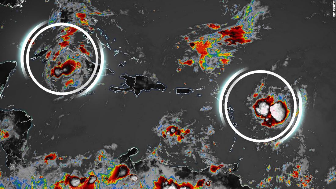
Tropical Depression Fred, circled on the left, and Tropical Storm Grace at right.
CNN —
As Fred remained a tropical depression overnight and moved toward the eastern Gulf of Mexico, Tropical Storm Grace became the seventh named storm of the season on Saturday.
Earlier a tropical depression, Grace strengthened to tropical storm status about 400 miles east of the Leeward Islands in the Atlantic Ocean, according to the National Hurricane Center.
CNN Weather
Both storms are expected to bring heavy rain and flooding, with Grace prompting a tropical storm warning for parts of the eastern Caribbean, including the US Virgin Islands and Puerto Rico.
Maximum sustained winds are roughly 40 mph, with some strengthening expected during the next couple of days.
On the current forecast track, the center of Grace is expected to move over the Leeward Islands Saturday night, the Virgin Islands and Puerto Rico on Sunday and the Dominican Republic on Monday. Weakening is expected early next week as the system interacts with the Greater Antilles.
The US Coast Guard set port condition Yankee for ports in Puerto Rico and the US Virgin Islands on Saturday morning, meaning gale-force winds are expected within 24 hours.
The ports are closed to all incoming commercial traffic, the Coast Guard said in a release.
“Pleasure craft owners are advised to seek safe harbor and pay close attention to any changes in weather forecasts and small craft advisories throughout the weekend,” the release said.
The Coast Guard also advised people to stay away from beaches and to be prepared to leave the area.
CNN Weather
The track issued on Saturday morning of Tropical Depression Fred and Tropical Storm Grace over the next five days.
Drenching Cuba with rainfall, Fred had sustained winds of 35 mph, according to a Saturday morning update from the NHC.
“Fred is being maintained as a tropical depression for now, but data from the Air Force Hurricane Hunters later this morning will likely confirm if it is a depression or not,” the hurricane center said.
Fred is expected to pass to the west of the Florida Keys Saturday and could restrengthen after previously weakening to a tropical depression. Tropical storm-force conditions are expected across the Keys, and a few isolated tornadoes are also possible Saturday afternoon across central and southern Florida.
A tropical storm warning remains in effect for the Florida Keys west of the Seven Mile Bridge to the Dry Tortugas. Such warnings mean that tropical storm conditions are expected somewhere within the area within 36 hours, according to the hurricane center.
A State of Emergency was issued Friday for 23 counties, including Bay, Calhoun, Citrus, Dixie, Escambia, Franklin, Gadsden, Gilchrist, Gulf, Holmes, Jackson, Jefferson, Lafayette, Leon, Levy, Liberty, Manatee, Okaloosa, Santa Rosa, Taylor, Wakulla, Walton and Washington counties, according to Florida Gov. Ron DeSantis.
Through Monday, 3 to 5 inches of rain with local amounts of 8 inches are anticipated across the Keys and southern Florida. Fred is forecast to continue north across the Gulf, making landfall near the Alabama-Florida border on Monday evening.
Across the Florida Big Bend and Panhandle, 3 to 7 inches are expected with isolated maximum totals of 10 inches.
CNN Weather
From Monday onward, heavy rain and flood impacts could extend into inland portions of the Southeast.
CNN’s Judson Jones, Rebekah Riess and Alta Spells contributed to this report.
![]()


