

Tsunami warning issued after Pacific island of Vanuatu is rocked by 6.8 magnitude earthquake
Tsunami warning issued after Pacific island of Vanuatu is rocked by 6.8 magnitude earthquake
The earthquake struck near the coast of Port-Olry on Wednesday morningThe Pacific Tsunami Warning Center warned of possible tsunamis up to 180 miles (300 km) from the epicentre 25 percent of Vanuatu’s 276,000 citizens lost their homes in 2015 due to Cyclone Pam, a category five stormThe frequency of extreme weather conditions and natural disasters in the area is projected to increase
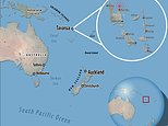
An earthquake of magnitude 6.8 struck near the coast of Port-Olry, Vanuatu, Wednesday morning, triggering a tsunami warning for nearby areas.
The quake was triggered at a depth of 56 miles (91 km) and was about 12 miles (19 km) north-west of Port-Olry, according to the US Geological Survey (USGS).
The Pacific Tsunami Warning Center said hazardous waves were possible for coasts located within 300 km of the epicentre.
USGS had initially put the magnitude at 7.1 and the depth at 51 miles, but these figures were later revised.
The quake was triggered at a depth of 56 miles (91 km) and was about 12 miles (19 km) north-west of Port-Olry, according to the US Geological Survey (USGS)
Vanuatu is one of many Pacific nations which have endured increasing numbers of extreme weather conditions, disasters and rising sea levels
Vanuatu is a South Pacific Ocean nation comprised of dozens of small islands that stretch over 800 miles, known for their coral reefs, underwater caverns and shipwrecks
Vanuatu is a South Pacific Ocean nation comprised of dozens of small islands that stretch over 800 miles (1300 km).
The islands are known for their coral reefs, underwater caverns and abundance of shipwrecks, some of which are WWII era American battleships.
The area has contended with increasing instances of extreme weather conditions, natural disasters and rising sea levels in recent years, which most experts believe is due to the effects of climate change.
Satellite data shows the sea level has risen about 6mm per year around Vanuatu since 1993, a rate nearly twice the global average, while temperatures have been increasing since 1950.
25 percent of Vanuatu’s 276,000 citizens lost their homes in 2015 when Cyclone Pam, a category five storm, devastated the South Pacific archipelago of 83 islands and wiped out two-thirds of its GDP and demolished 17,000 buildings.
Since the devastation of Cyclone Pam, local residents have reverted to constructing their buildings in a more traditional fashion, as the more modern concrete buildings with iron rooves were blown away.
Though difficult to assemble, the traditional ‘cyclone houses’ are made of thatched coconut palm fronds, wild cane and bamboo strips which are secured together using vines sourced from local forests.
However, such structures are more vulnerable to tsunamis and flooding, which is cause for alarm given the rapidly rising sea levels around the islands and the frequency of natural disasters such as earthquakes.
Vanuatu became well-known in Britain when it emerged a tribe on the island had worshipped Prince Philip following his visit with the Queen in 1974.
The royal connection with the tribe continued when Prince Charles paid a visit to Vanuatu in 2018, following in his father’s footsteps.
![]()